
 This is just in time for all those teams considering building a robot lunar rover to win $20 million in the Google Lunar X Prize.
NASA said Tuesday that it has added new lunar imagery to Google's Moon Web site, a photographic display of the moon with information graphics about the Apollo landings.
The additions are part of an ongoing partnership between NASA and Google, which signed a Space Act agreement in December 2006 to work on Web projects together. NASA, for example, recently added photographs taken from the satellite sensor Landsat into Google Earth.
The updated moon site includes higher resolution lunar maps and additional content from the Apollo missions, including panoramic images, audio and video clips, and descriptions of the astronauts' activities, according to NASA. The site also features detailed charts of different regions of the moon "suitable for use by anyone simulating a lunar mission," the space agency said.
"NASA's objective is for Google Moon to become a more accurate and useful lunar mapping platform that will be a foundation for future web-based moon applications, much like the many applications that have been built on top of Google Maps," Chris Kemp, director of strategic business development at NASA's Ames Research Center, said in a statement.
Google and the nonprofit X Prize Foundation announced earlier this week that they will offer $20 million to the first team that can put a robotic rover on the moon that can travel 500 meters. (It is offering an additional $5 million for second place, and $5 million for bonus feats.)
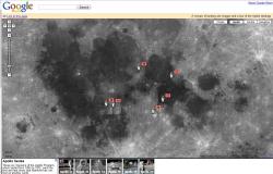
When Google Moon was released last year, it was a bit of a joke. Google Earth, but for the Moon. Zoom in far enough and the familiar lunar craters were replaced with swiss cheese. The time for silliness is over, Google Moon has gotten an update, and they're making it a serious learning tool this time around. The website incorporates photographs from orbiters and the Apollo missions to let you zoom in and out, exploring the Moon.
Head over to Google Moon, and follow along. You can change the view between Charts, Apollo, Visible and Elevation. All of the Apollo landing sites are marked on the map, so you can click each one to get more information.
Zoom in all the way, and you don't see swiss cheese anymore. Instead you see the most detailed images available from NASA showing high resolution details about the landing sites. Each landing site has more than 10 additional detailed place markers, showing points of interest about the mission.
For example, click on the Apollo 16 mission, and the interface informs you there are 21 additional place markers. Click to zoom in, and you can see all the little markers. Click on any one and you'll see more details, such as interesting rocks, craters, and landing spacecraft. Some of the detailed views are just photographs, but others are panoramas that you can scroll around to see the landscape from the astronauts' point of view. Very cool!
There are also some landmarks with audio clips and video clips. All in all, the site feels like an educational CD-ROM.
And that's part of its problem - it's not really an atlas of the Moon, and more of a presentation of the Apollo missions. Many of those lunar craters have names. There are plenty more interesting features on the Moon than just the Apollo landing sites. I'd love to see some of that information incorporated as well. They could also bring in images from other spacecraft, like ESA's SMART-1 to provide better coverage in some areas.
My other concern is that it doesn't really work if you zoom all the way out. Instead of seeing a nice view of the whole Moon, there's a confusing set of repeating images showing the same portions of the Moon over and over again. Google Maps does the same thing with the Earth, but still, it should look like you're zooming into the Moon.
No comments:
Post a Comment